Gallery Highlights
In this highlights section of the BuyNow catalog, we present some personal favorites from our large stock of authentic maps, atlases, prints, globes, posters and Medieval manuscripts.
The items are immediately available, and no commission is charged.
Feel free to contact us if you have a question or if you are looking for a specific item.
Be the first to get notified!
Subscribe to our Newsletter to be notified when new items becomes available.

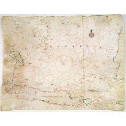
One of the few manuscript charts on vellum in private hands, signed by Isaac de Graaf. ORIGINAL MANUSCRIPT MAP IN RED, GREEN, AND BLACK INK showing the Java Sea centered on the Island of Java, the Southern part of Borneo, and parts of Sumatra, with Bali Island nearby.
-256x256.jpg)
AN EARLY ISSUE of this biting and vulgar satire on the Mississippi and South Sea Bubbles and an extraordinary visual record with 78 plates of the first banking crash, showing the shocking effects of the “South Sea Bubble” in France, England and Holland, and placing John Law (1671-1729), with his Mississippi company scheme, squarely at the center of the disastrous chain of events.
Lucas Janszoon Waghenaer (1533-1606), one of the brightest lights of Dutch Golden-Age mapmaking, distinguished himself from many of his fellow stars by some 14 years of seafaring
-256x256.jpg)
-256x256.jpg)
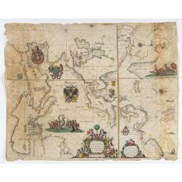
Rare and highly important chart of the Indian Ocean extending from the Cape of Good Hope to the Far East and Australia, printed on vellum, covering the east coast of Africa, the Arabian Peninsula, India, South East Asia, the East Indies, and with an important delineation of Australia. This is one of the preeminent charts from Johannes van Keulen's oeuvre and one of the great Indian Ocean maps. The plates for this map were originally prepared by Pieter Goos in circa 1658.
-256x256.jpg)
An important and rare atlas by the Danckerts family: containing 86 maps and double plates, most in color, titled in Latin, sometimes in Dutch or French: With an allegorical title; six plates; two spheres; seventy-seven maps are numbered in pen.
-256x256.jpg)
General 1734 large-format map of the Russian Empire compiled by Ivan Kirilov (1689/1695]-1737), the Chief Secretary of the Governing Senate in St. Petersburg in 1734. This is the first general map of the state to be created in Russia on a scientific basis: using the system of astronomical reference points, a grid of conic projection, the latest expedition data, and materials from the first instrumental surveys of individual territories of the country.
NIEROP (Dirck Rembrandtsz van) - GOOS (Pieter) - Wassende graade paskaart vertonende alle de Zeekusten van Europa, Amsterdam, Pieter Goos, [1658]. Printed on vellum, with outlines enhanced in watercolor.
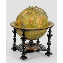
To our knowledge, the only known example of this 12-inch (32,5cm.) celestial library globe, published by "one of the foremost cartographers of the age (Shirley), here in its scarce first address "Rue des Canettes" and dated 1700.
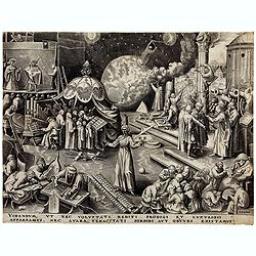
Temperance (Temperantia) from The Virtues by Pieter Breughel. Antwerp, Hieronymus Cock, 1580